Introduction to Kanchenjunga Circuit Trek
Kanchenjunga itself lies on the far eastern side of Nepal, near the border with Sikkim, a tiny Himalayan state in the north-eastern part of India.
Until mid-1800, it was thought Kanchenjunga was the highest peak in the world.rnrnThis area was closed to trekkers until the mid-1980. Today the region is protected by the Kanchenjunga Conservation Area and a special trekking permit is required.
With these restrictions, the beautiful and unique flora and fauna of this area is still in pristine condition today.
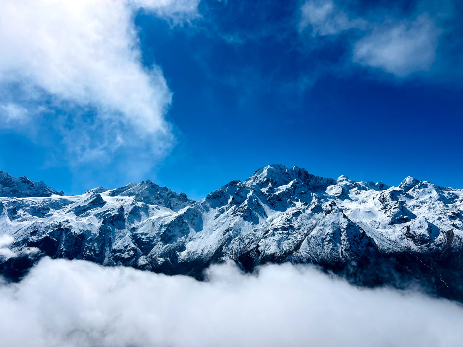
With regards to the mountains themselves, in addition to the main peak of Kanchenjunga, there are four subsidiary summits exceeding 8,000m, the most important being Kanchenjunga West, also known as Yalung Kang (8,505m).
Also found in this area are approximately twenty peaks exceeding 7,000m, the highest being Kambachen (7,903m), Janu (7,710m), Jongsong (7,483m), Kabru (7,353m), Tent Peak (7,365m) and the Twins (7,350m).rnrnIn addition, there are numerous peaks over 6,000m. Amongst this impressive cluster of peaks are five major glacial systems.
Of these, Zumu, Talung and Rathong flow into Sikkim while to the west, the Kanchenjunga and Yalung glaciers flow into the mighty Tamor River of Nepal. This just adds to the fact trekking in Kanchenjunga is an unforgettable experience where trekkers get right into the heart of the remote, less trekked, Himalaya mountains and valleys.
With the recent addition to the trekking map of the Great Himalayan Trail, tourism is being promoted in this, as well as other, remote areas so there is the opening up of more teahouses on the route. While this is positive for the local communities, now would be a good time to go to Kanchenjunga before more trekkers ‘discover’ the area!
Kanchenjunga Circuit Trek Itinerary
After breakfast, our guide will collect you from your hotel and accompany you to the airport. The short flight to Bhadrapur takes us over the Kathmandu Valley and surrounding hill and through some of the mountains Nepal is famous for. A free mountain flight! On arrival in Bhadrapur, we will drive to Fikkal/Kanyam, the heart of the tea plantation area of the country.
Next day, we drive north east to Taplejung, the district headquarters and official starting point of Kanchenjunga Circuit Trek. The road is a mix of paved and gravel surface, often narrow and prone to landslides during monsoon.
The drive passes through rolling hills, terraced farmlands and cardamom growing villages. Although long and tiring, it gives you an idea of how remote trekking in eastern Nepal is.
Taplejung has more developed infrastructure than previous stops. Hotels, shops, hospital and even a bank with ATM are available. We should use this opportunity to buy snacks, batteries, SIM cards or trekking poles.
Cultural presence is mostly Limbu and you will see traditional temples and wooden houses with intricate carvings. Altitude at Taplejung is under 2,000 meters so it’s still relatively low in terms of acclimatization but the landscape starts to show Himalayan terrain.
Day 3 is the official start of the trek. The trail descends from Taplejung to Tamor River Valley and then follows Ghunsa Khola upstream. The path has steep downhill sections, stone steps and some minor ascents. It goes through subtropical forests and rural settlements with cultivated terraces of millet and maize. Limbu and Rai villagers are seen farming or carrying loads in bamboo baskets.
This day also marks your entry into the Kanchenjunga Conservation Area, a protected zone that requires trekking permits. Trekkers cross several suspension bridges and walk along rivers and cliffs, making this section moderately challenging but scenic. Humidity can be high and the trail can be muddy in sections – especially in spring or after rainfall.
Sekathum is a small riverside village with 2–3 teahouses with basic facilities: twin-sharing rooms with thin mattresses, simple Nepali meals (dal bhat, noodles), and boiled water. Electricity may be limited and mobile signal is weak or non-existent.
Day 4 is one of the steepest ascents in the early part of the trek. The trail follows Ghunsa Khola and climbs through thick bamboo and rhododendron forests. The path has several suspension bridges and narrow cliffside sections that require careful foot placement. This is one of the more physically demanding days, especially for first-time trekkers or those carrying heavier packs.
Wildlife such as langurs, red pandas and Himalayan monals inhabit this forest zone but sightings are rare. Human settlements are few but you may see Tibetan yak herders or temporary shelters used during grazing seasons. This is the start of higher elevation trekking and early signs of altitude sickness (fatigue, short breath) may appear.
Amjilosa is a very small village with just a couple of teahouses. Rooms are basic – often wooden cabins with no insulation. Evening temperatures can drop significantly even though it’s still below 3,000 meters.
After breakfast, we head off through different forests of pine, bamboo, rhododendron and oak. We notice the villages and people are becoming more Tibetan like.
We also see yaks, sheep and goats on the trail, not to mention a good variety of birdlife. After lunch the trail takes us up through dense forest cover and over a wooden bridge on to Gyabla where we spend the night.
Today the trail continues on through forests and passed Phale Village which was a Tibetan refugee camp started decades ago when Tibetans started fleeing from the communist regime in China.
Today it is a winter settlement village. We have time to visit the village where there are some handicrafts for sale. We head to Ghunsa, the largest village in the area and one with a police station, health post and a Kanchenjunga Conservation Office. Telephone and internet services are available here.
We are now at higher altitude and aiming to go higher! So we take the opportunity to relax and acclimatize in Ghunsa. There is a monastery to explore and a ridge to climb.
From the ridge there are views of Jannu Peak which is worth the 5 hours plus round trip. Should you wish to climb up the ridge – and we recommend this as it helps acclimatize our bodies – we will take a packed lunch with us.
Views of the Jannu Himal dominate the skyline today. Following a gentle upwards path we come to a green glacier valley. Here we may be lucky to spot blue sheep and snow leopards. The trail continues on past a waterfall to a landslide-prone area where we take particular care.
Again we take the chance to acclimatize our bodies to the altitude and in preparation for our visit to the North Base Camp. We can climb another ridge today where we get stunning views of Kanchenjunga.
Today the trail takes us mainly over moraine from the Kanchenjunga Glacier. Walking uphill over large boulders there are wonderful views on both sides of us.
And as we are deep in Snow Leopard territory we keep our eyes open for this rare animal too! This is also an area of summer yak pastures but there are no settlements on the route.
Kanchenjunga North Base Camp, also known as Pangpema, is the final point of the Kanchenjunga North Trek, sitting at an altitude of approximately 5,143 meters (16,873 feet). It offers breathtaking views of Kanchenjunga (8,586 meters), the world’s third-highest mountain, along with other towering peaks like Tent Peak and Chang Himal. The route to the base camp passes through remote villages, dense forests, high-altitude meadows, and glacial moraines, making it one of the most adventurous treks in Nepal.
Due to its rugged and isolated location, there are no tea houses at Pangpema, so trekkers usually stay at Lhonak and hike to the base camp as a day trip. The landscape is stark yet awe-inspiring, with dramatic ice walls and glaciers surrounding the area. Since this trek reaches extreme altitudes, proper acclimatization and physical fitness are essential. Reaching Kanchenjunga North Base Camp is a challenging but rewarding experience, offering some of the most pristine and untouched mountain scenery in Nepal.
On Day 13, we descend from Lhonak (5,065 meters / 16,617 feet) to Ghunsa (3,475 meters / 11,401 feet), retracing our steps through stunning alpine terrain. The trail passes Ramtang and Kambachen, with continued views of Kanchenjunga’s north face. Though the descent eases the strain on your lungs, sections remain rocky and require careful footing. Wildlife such as blue sheep and signs of snow leopards are often spotted in this remote valley, adding to the experience.
As we drop nearly 1,600 meters (over 5,200 feet) in altitude, the landscape softens into lush forest. By late afternoon, we arrive in Ghunsa, a welcoming Sherpa village with wooden houses, prayer flags, and a tranquil monastery. Magical Nepal ensures a comfortable stay here, offering well-chosen lodges and nourishing meals—perfect for rest and recovery before the journey toward the southern base camp.
Today the trail takes us through a forest and along a grassy ridge from where we can see Ghunsa and Phole villages as well as Mt. Makalu in the distance.
We start out early this morning towards the Kanchenjunga South Base Camp. Crossing the Sinion La pass (4,450m) the trail takes us along a ridge to Sinelapche La pass (4,830m).
From here the views of Mt Kanchenjunga and its valley are fantastic. We descend along a small trail to Cheram, the only settlement we find on this route. We overnight here.
Today we trek to Ramche where we stop for lunch before walking on for around 40 minutes to reach Kanchenjunga South Base Camp. The Base Camp is right on the edge of the glacier and surrounded by Tibetan prayer flags. We return the way we came to overnight at Cheram.
The trail descends steeply from the alpine zone to temperate forest. You retrace part of the trail past Cheram and then turn west into dense rhododendron and pine forests. This area is within the Kanchenjunga Conservation Area and wildlife sightings are possible – look for Himalayan monals, barking deer or even red pandas.
The trail has steep steps, slippery switchbacks and occasional landslides. Use trekking poles to reduce impact on your knees. Torongding is a quiet settlement with 2 teahouses and minimal amenities. There is no internet and charging devices may cost extra (Rs. 300-500 per device). Water is available from natural springs but must be purified or boiled. This descent helps trekkers adjust back to lower altitudes and increase appetite and sleep quality
This day is continuous downhill walking through a lush and humid environment. The trail goes through bamboo groves, cardamom plantations and subtropical forests. Leeches are common in this region especially after rain so wear leech socks or gaiters.
We will pass through Chhetri and Limbu settlements where traditional mud houses and terrace farming dominate the landscape. Language spoken is mostly Limbu but basic Nepali is understood. Solar panels are used in homes and livestock like buffalo, goats and chickens are common. We’ll reach Rani Pul by afternoon – a small roadside settlement with jeep access and a few roadside eateries or guesthouses.
From Rani Pul a local 4WD jeep (usually a Mahindra Bolero or Tata Sumo) takes us back to Taplejung. The drive follows the Kabeli River and ascends through green ridges and farmland. This region is famous for cardamom cultivation which is the main source of income for local communities. Roads can be blocked during monsoon (June to September) so flexibility in itinerary is necessary.
In Taplejung you’ll find hotels with private rooms, electricity, Wi-Fi and hot showers – not available in previous trekking villages. There are also ATMs, pharmacies and local shops. Taplejung is the administrative and commercial center of the area and is the official endpoint for most Kanchenjunga trek itineraries.
This long drive brings you back to the lowlands of Nepal. The route passes through Phidim, Ilam and Fikkal – towns famous for tea estates and commercial markets. You’ll see a change in landscape from Himalayan foothills to flat plains. The road is mostly black-topped after Phidim though some stretches are rough. You’ll reach Bhadrapur in the late afternoon or evening.
Not satisfied with this Itinerary? Are you interested on planning custom trip? It only takes 2 minutes.
Annapurna Basecamp (6Days) Treks,